


Something strange and significant is happening deep beneath the Pacific Ocean, and it has scientists genuinely worried about what’s coming next.
Researchers have picked up on a massive underwater structure called a Kelvin wave — essentially a huge pool of warm water quietly traveling eastward below the ocean’s surface. And we’re not talking about slightly warmer than usual.
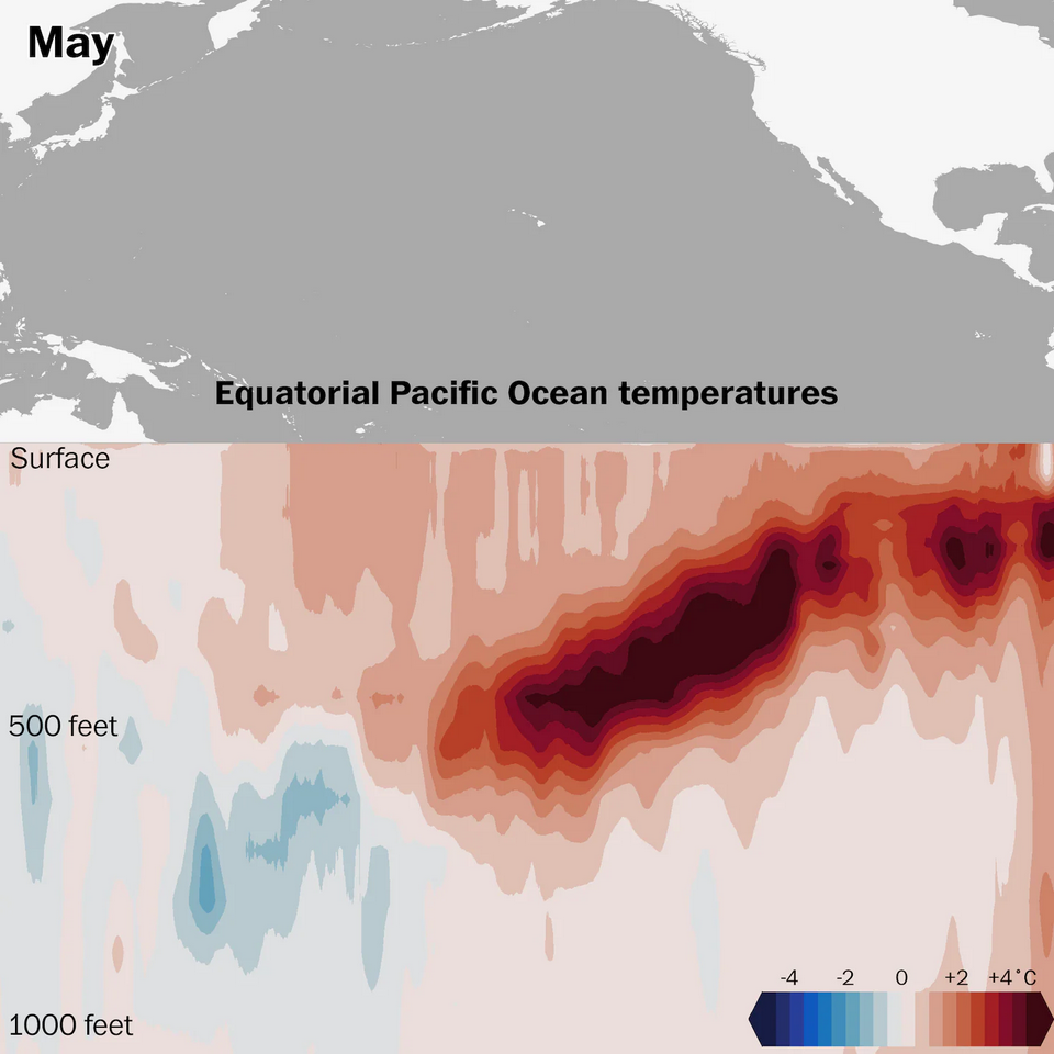
In some areas, temperatures inside this wave are running about 13.5°F above average. That’s a striking anomaly, and the concern is that it could supercharge the next El Niño into one of the most powerful the world has seen in recent decades.
So what exactly is El Niño? Think of it as the Pacific Ocean running a fever. When Pacific surface waters become unusually warm, global weather patterns shift sharply. Winds and rainfall systems are disrupted across many regions.
According to NASA, El Niño can weaken monsoons, trigger floods in South America and raise global temperatures.It’s one of those natural phenomena that reminds you just how connected everything on this planet really is.
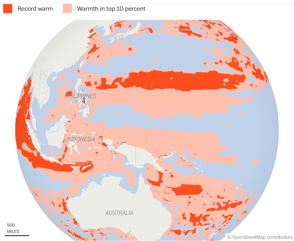
What makes this moment particularly unsettling is the backdrop it’s playing out against. Ocean temperatures aren’t just elevated in one spot — they’re at record highs across the board. Data from the EU’s Copernicus Climate Change Service revealed that global sea surface temperatures hit 21.06°C in February 2024, the highest ever recorded for that month.
Scientists are watching this wave arrive into an ocean that’s already running hot, and that combination is what’s raising alarms.
For India, the risks are serious. The monsoon drives the country’s agriculture and economy. Nearly 55% of India’s farmland still depends on rainfall. A weak monsoon hurts crops, rural incomes and food prices. It also affects millions of people across the country.
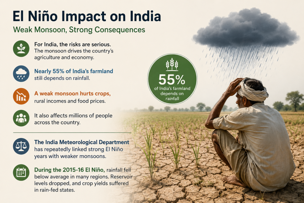
The India Meteorological Department has repeatedly linked strong El Niño years with weaker monsoons. History supports that trend. During the 2015-16 El Niño, rainfall fell below average in many regions. Reservoir levels dropped, and crop yields suffered in rain-fed states.
There’s also a larger, more troubling pattern emerging. Climate scientists warn that global warming isn’t just sitting alongside natural weather cycles — it’s actively amplifying them. Warmer oceans appear to be making El Niño events more intense and harder to predict, which means the traditional playbook for managing their effects may not be enough anymore.
The fallout extends into the oceans themselves. Coral bleaching is accelerating, fish populations are under pressure and marine heatwaves are becoming more frequent. A stronger El Niño would only add fuel to trends that are already moving in the wrong direction.

Experts are clear that early preparation matters enormously here. Smarter water management, adaptive crop planning and readiness for extreme heat events could all make a meaningful difference — but only if governments start acting before conditions deteriorate rather than after.
There’s something almost poetic about the conclusion climate scientists are quietly arriving at: India’s farmers and policymakers may need to start watching the Pacific Ocean as carefully as they watch the sky above their own fields. Because increasingly, what happens out there determines what happens here.
Reference- Vox, The Guardian, Futurism, NOAA website, The Washington Post, Wall Street Journal